Dynamic Predictables LLC,   Columbia, MO 65205-1365, USA       dynapred@dynapred.com   tele +1.573.815.0520                        multi-year, site-specific and regional climate prediction                 

DP Home
ATLAS
What's New
Services
About
 Predictions
Archives
Support
Feedback
Links
Disclaimer

The Nino3-9805  page shows observed and predicted Nino 3 (5N -5S, 150W-90W) Anomalous Sea Surface Temperature (SST).).  December 2009 (200912) is the last updated observed (blue triangle) point on all charts.  Beginning blind prediction 05/1998, this Nino 3 was the sole SST prediction presented to the American Association of State Climatologists (AASC) Annual Meeting at Duluth Minnesota in August 1998.  The monthly SST data used in producing the figure was obtained courtesy NOAA's ftp site and can be found at:   ftp://ftp.ncep.noaa.gov/pub/cpc/wd52dg/data/indices/sstoi.indices 

A revised NINO3-9805 prediction run was made in June 2003.  Using the same 199804 ending data and using current models, the 'new' run is regarded as sufficiently accurate for use through 2005 and beyond.  The new chart may be accessed through the above navigation bar or clicking NINO3-9805_Nino3-0304 and the 1998 chart is at the top of the page.   Updated monthly observations will be provided to aid interpretation and the prediction remains the same.  The end data point used in prediction is marked by the oversized black circle at 199804.  The most recent updated observed point is indicated on each chart as end date of the correlation statistics.  The press release dated 20030620 (June 20, 2003) is placed below the chart.  This revised DataEnd 199804 prediction has been regarded as the most accurate of the three charts (original 9805,  this Nino3-9805_0305 (also referred to as DataEnd 199804), and the following DataEnd 200304) presented here. However, beginning mid 2010 the 200304 shows comparable correlation to observed.   For comparison purposes, the NINO3 Anomaly chart (placed 20030630) using the same prediction model as for Nino3-9805_0305 but with input data through 200304 is included at bottom of page and labeled as Nino3-0304_0305.  Please note similarities and differences for the observed and predicted periods.  Predicted 2004-05 warm (El Nino), 2006 cool (La Nina) and 2008 warmer El Nino are especially noteworthy.

Press Releases featuring Sea Surface Temperature (SST) will be placed from time to time on most appropriate web pages--including initially the What's New and the source prediction reference page.   NINO3-9805_Nino3-0304  has been so referenced for releases 20030620 and 20040427 heralding NINO3 Anomaly developments and DynaPred's predictions thereof.  After an appropriate time, such releases will be graduated to this page.

20060217.  Doug O'Brien and Gregg Suhler at American Association for the Advancement of Science (AAAS) 2006 Annual Meeting in St Louis speak on "Nino3 Intradecadal Predictability: Regional and Site Specific Implications".  Suhler organized the Symposium "El Nino Predictability".


Archival and occasional comments follow in reverse chronological order::

PRESS RELEASE:  Hurricanes 200604 Outlook
Dynamic Predictables 20060406 http://www.dynapred.com t  +1-5738150520 Al Peterlin

With the devastation of last season's tropical storms still lingering over the battered and bruised Gulf Coast, the United States is now bracing for the June 1 opening of the 2006 hurricane season.  Even as we look to the tropical Atlantic, the tropical eastern Pacific is signaling the tropical storm supporting La Nina climate pattern will diminish thru the early summer months but will build again into the fall.

Many experts agree that while it will be unusual for the 2006 season to be as extreme as the 2005 season, this season's storm totals could still exceed the average (10 named, 6 hurricane, and 2 intense).  And, Dynamic Predictables sees some reason to expect coastal landfall again in the Gulf this season as well as some along the eastern seaboard.

While Dynamic Predictables does not focus on predicting hurricane intensity, number, or coastal strike probability as such, we've learned that our physics based predictive methods offer insight that is useful at times, even when discussing hurricanes.  Hurricanes deliver a lot of rain, and Dynamic Predictables does fairly predict precipitation on a monthly basis.  Dynamic Predictables long range precipitation outlooks highlight some coastal moisture in the Carolinas beginning in June 2006 and expanding into July and August. In addition, consistent moisture shadows develop along the coastal Gulf in July and August.  Our preliminary work indicates the 2006 hurricane season this year will be most active early rather than late whereas 2005 was active early, middle, and late. And we could see coastal impact not only in the Gulf but this year along the eastern seaboard.  The specifics are available to commercial clients.


Press Release:  Dynamic Predictables 20051011

La Nina, Hurricanes and Drought?

Dynamic Predictables is calling for the ENSO neutral (NADA NINA) conditions that have been dominant across the tropical Pacific since April 2003 to continue the gradual decline into a weak to moderate eastern Pacific La Nina by Christmas and linger over into early 2006.

Tropical waters remain summer warm, especially in the eastern Pacific and the western Atlantic. Readings are not significantly anomalous except along the Chilean coast where La Nina blooms.   However, Atlantic Basin tropical storms development is known to be accommodated by unseasonably cool eastern Pacific temperatures (La Nina).  Conversely, unseasonably warm eastern Pacific conditions (El Nino) are unfavorable as upper level westerly winds work against important tropical storm buildup at those altitudes.

A regional but significant agricultural drought occurred in the heart of the US Midwest in 2005 when an Illinois high pressure center proved more resilient than the moderate Bermuda High that anchored itself off the eastern seaboard much of the crop year. While tropical storms dampened otherwise dry Gulf coastal areas (Louisiana, Mississippi and Arkansas) before tracking northward across the Mississippi and Ohio River drainage, inland areas to the north and west tended to display incipient or seminal 2006 crop year drought.  End of season (2005) soil moisture conditions could spread precipitously during the US 2006 crop year, a potential that is historically favored when Eastern Pacific surface waters are unseasonably cool, otherwise called a La Nina event.

For the remainder of this 2005 hurricane season, upper level 500 mb tracking flow is displaced northward in a lingering warm season pattern. A weak steering pattern should not interfere with late tropical storm development.  Combined with the ongoing eastern Pacific cooling pattern and continued warm waters in the main Atlantic generating area, tropical storm development up through hurricane level is possible through the remainder of this already record-nearing active 2005 season.

Dynamic Predictables Nino3 predictive algorithm supported press releases in 2003, 2004, and 2005 and has successfully heralded the sea surface temperature decline from May 2005 temperature peaks (mild El Nino) en route to a La Nina winter 2005-06.  This may be a contributing factor to the westward extension of hurricane track formations into the Gulf of Mexico, and to the lack of upper elevation westerly winds thereby permitting stronger tropical cyclone development.

Contact:  Al Peterlin  +1-717-329-4748 or Gregg Suhler +1-573-815-0520    http://www.dynapred.com   


Press Release: on web 20050430:   observed temperatures have been updated past 200503 at release

Press Release: April 29, 2005

ENSO Two-Slide Step: May upswing; Christmas bow.

A nearly two-year, mild El Nino finishes with an upsurge in May, and then Eastern Pacific Sea Surface temperatures bow to Christmas lows with broad global impact implications.

Columbia, Missouri--Dynamic Predictables today suggested a 23-month long, weak El Nino or warm period will end with a sharp uptick through May 2005.  Nino 3 Eastern Equatorial Pacific sea surface temperatures have been above average since July 2003 but never quite to the 1.0 degree C historical El Nino threshold.  May temperatures are expected to range 0.90 to 1.35C above the 1950-79 average. With a +0.38 Celsius average for 21-months through March 2005, the duration of this event has been slightly longer than average and slightly milder than typical warm events.

After the May 2005 peak, Nino3 Eastern Pacific region sea surface temperatures will fall to mild to moderately cool La Nina levels  (range -0.3 to -1.0 degree C) by Christmas 2005.

Since July 2003, the ENSO event commonly referred to as El Nino has been centered in the central to western 
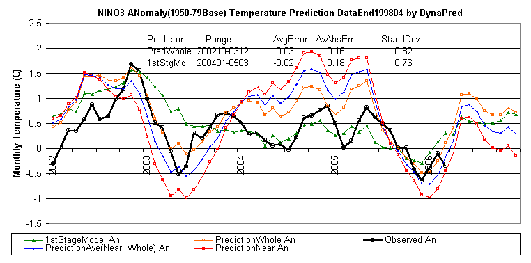
Pacific, away from the historical El Nino regions just off the Peru-Ecuador coast.  The ENSO Two-Slide Step refers to observed NINO3 Anomaly tracking two DynaPred prediction modes from October 2002 through March 2005.  Details with chart are available at http://www.dynapred.com  .

NINO3 observations tracked the main long term climate dynamics mode during the 15 months 200210-200312 and then primarily tracked Dynamic Predictables 1st Stage Model the next 15 months, 200401-200503.   Average Error on order of 0.02 C and Average Absolute Error on order of 0.2 C in context of corresponding months' Standard Deviations (1950-79 basis) of 0.80 C was obtained. NINO3 last showed this type of sequential mode persistence in the early to mid 1990s.

El Nino conditions frequently imply generous moisture for crop growing regions of the United States with La Nina trending drier. The reverse is true for many Equatorial and Southern Hemisphere regions.

Dynamic Predictables is a private company providing climate predictions and climate impact assessment for the agriculture, construction, distribution, energy and media industries. Monthly time-step predictions are available at web site: http://www.dynamicpredictables.com  .

Contact:
Gregg Suhler: +1-573-815-0520
http://www.dynamicpredictables.com   or
Albert Peterlin: +1-717-329-4748

Dynamic Predictables, LLC
http://www.dynamicpredictables.com
suhlerg@dynapred.com


[DP Home] [ATLAS] [What's New] [Services] [About] [Predictions] [Archives] [Support] [Feedback] [Links] [Disclaimer]