|
|
 |
|
|
|
|
|
|
|
|
|
|
|
|
|
|
What's New . . .
|
|
|
|
(Leading few items may be out of chronological sequence-- see or click here Chronological Sequence below. Topical Press Releases such as ENSO and the like, appear at top of this section. Regularly scheduled Monthly CONUS graphic Outlooks and Press Releases appear in Chronological Sequence section below. Included in Chronological Sequence now is the Weekly Commentary April through November featuring pre-NASS USDA crop condition report by Al Peterlin--posting on Monday mornings usually by 0830 excepting Federal holidays.
|
|
|
|
20100215. AAAS2006 Annual Meeting symposium #127 on El Nino Predictability showed the derivation from the interactive Navier-Stokes equations of the binary subharmonic sequence often found in forced
systems, Earth's climate being among them. A particular but oft-obtained and maybe the most interesting system response with feedback solutions are given by the following formula for periods T
as multiples of the primary driving force period To
T(N,M) = [(2**N)n(To)/m]N,n,m=1,2,3...M
for each sequence N. In case of Earth's climate, this generates a sequence of 2**N years where N is +/- 1,2,3,... so that (here) partial sequences are obtained:
...1/16, 1/8, 1/4, 1/2, 1, 2, 4, 8, 16, 32, 64...
This period doubling phenomenon is a particular case of the more general solution form for m,n=1,2,3... which has been called an "ultrasubharmonic (USH)
sequence" (Enns and McGuire, 2001).
Most importantly such phenomena are found in nature.
This approach provides explanatory power for what is observed and provides a fundamental basis for monthly time-step, multi-year prediction as practiced by Dynamic Predictables. A shortened version of the AAAS2006 presentation was made at American Association of State Climatologists Annual Meeting in 2006 (below) and click on 23-01-Suhler-Enso.ppt presentation in the zipped Day 3 presentations file.
http://www.stateclimate.org/meetings/default.php?meeting_year=2006
Or one can download the AASC2006Suhler (535kb) file, with apologies to AAAS where we are a bit overdue on pubishing from the 2006 Annual Meeting.
|
|
|
|
20100114. DynaPred's first prediction chart, Nino3 Anomaly began 199805, is retired after 140 months. Comments, performance under Featured Chart on DPhome. Also at Nino3-9805 under Predictions/El-Nino.
|
|
|
|
20091215. DynaPred presentation at Japan agency METI/RIETI Brown Bag Lunch of 20071204 has link posted on DP Home Page about 4 inches down from top.
|
|
|
|
20090609. Atlas, the new 1-5 year forward temperature and precipitation product is introduced at its own page clickable page, ATLAS.
Accordingly this website will be in various stages of makeover until the process is completed.
|
|
|
|
20090317. Site-specific prediction location Sherwood3N, North Dakota, USA debuts with its own banner under Predictions.
Monthly precipitation input data ended 200106 and the prediction was first shown at a NOAA workshop July 22, 2004.
|
|
|
|
20041116. Dynamic Predictables 1st Stage Model Performance Comparison with CPC '30-day Forecast from 200207-xx12. Compares DP's 5+years ahead with NWS 30 day.
|
|
|
CHRONOLOGICAL SEQUENCE (REVERSE, recent first)
|
|
|
|
Weekly Commentary: Usually by 0830 Central (US) the morning ahead of USDA's NASS Crop Progress Report.
|
|
|
|
20110627. Released Monday June 27, 2011 at 0730 CDT (1100 GMT). Commentary by Dynapred's Al Peterlin--Predicting the dynamics of Monday's weekly USDA/NASS crop condition report:
If you look at the precipitation totals for the past week, it seems dry. If you review the
percent of normal precipitation, another story emerges. For much of the Summer crop area, moisture was again heavier than typical. This time, even some southeastern crop areas enjoyed some moisture. But, Texas and
the southwest across California remain dry. The temperature story also offers a cautionary tale. Temperatures across the north are cool. The south is warm and Texas and Oklahoma are blistering.
The NWS week 2 outlook offers more of the same, heat in the south and cooler than usual
weather from the Northern Plains to the western Great Lakes. The south will continue to bake under seasonally excessive heat.
So, cotton continues to struggle with trend direction firmly established. Corn and beans
seem settled in a pattern of condition - a façade of last year. Soil moisture is good to excessive. The crop is planted late, shallow rooted and depending on cooler than usual temperatures to flourish.
Real summer heat would hurt. Flooded acres the Dakotas and the lowland Mississippi Valley acres (those soaked to the core by the Corps) - will probably not firm and dry enough to support
even second crop beans. Hay might be a strong alternative as a cash crop for growers able to service the droughty south and southwest. End pre-NASS Commentary 20110627.
|
|
|
|
20110620. Released Monday June 20, 2011 at 0600 CDT (1100 GMT). Commentary by Dynapred's Al Peterlin--Predicting the dynamics of Monday's weekly USDA/NASS crop condition report:
Much of the southern half of the nation received less precipitation than usual this past week,
although portions of the Missouri and Mississippi River Basin remain flood troubled. The northern half of the nation was more spottily covered with heavy rains across portions of the Northern Plains, the upper Ohio
Valley and portions of New England. Temperatures are holding in a stable pattern with the north cooler than usual, the south warmer than usual.
The week2 outlook suggests warmer than usual weather from the Plains east. Moisture forecasts
heavier than usual across the Northern Plains and along the eastern Gulf then up the Eastern Seaboard from the Louisiana coast eastward to Florida and northward into Virginia.
For now, wheat production is what it is. The corn and bean crop is now in the ground, a bit
later than usual and with lots of lowland areas not planted. Production estimates are average, but it will take a moderate summer and some late season heat to push production. Interestingly, Dynamic
Predictables suggests some badly need rain for portions of the south and southeast. While not drought breaking, it would be one portend of improving conditions. End pre-NASS Crop Progress Report Commentary 20110620.
|
|
|
|
DynaPred's Atlas First Stage Model
Prediction maps as released for public use. Showing last two releases. See release schedule at bottom of DP Home page. Different layouts, views on DP Home page and under Predictions...Seasonal.
|
|
|
|
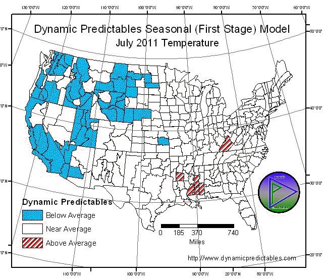
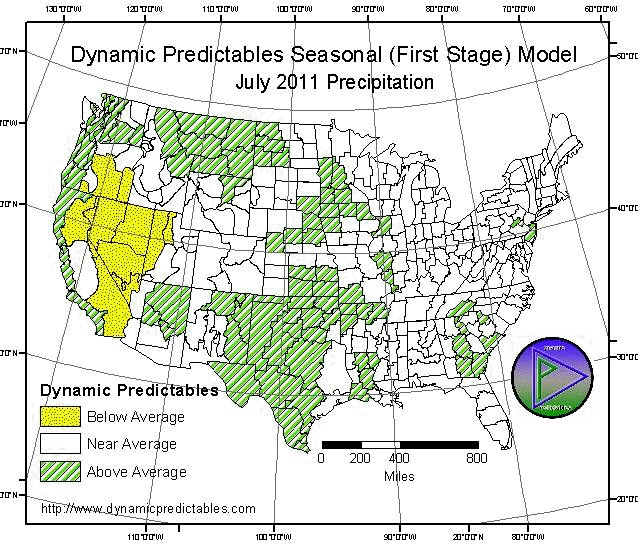
20110614, Tuesday June 14, 2011.
Covering all 344 continental US NCDC climate divisions, DynaPred's Seasonal (1st Stage) Model Outlook downloads follow. Then Press Release: July (201107)
DynaPred's Seasonal (First-Stage) Model Outlook:
July (201107) Temperature, download dynapred_1107temp.gif (99kb)
July (201107) Precipitation, download dynapred_1107prec.gif (92kb)
|
|
|
|
Press Release: Dynamic Predictables 201107 OUTLOOK issued 3 PM CDT 20110614
Dynamic Predictables releases for pubic use their Atlas
First Stage predictions for 30-day mean temperature and cumulative precipitation on the Tuesday prior to the third Thursday of each preceding month. Graphics with pattern and trend information for the United States
NCDC climate divisions can be viewed at: http://www.dynamicpredictables.com
July 2011 temperatures predict to be cooler than usual from Great Plains
west. Eastward of the Plains temperatures will be near seasonal average to above.
July 2011 precipitation predicts average to above from the Mississippi
River west with exception being a dry Great Basin and noncoastal California. Otherwise precipitation predicts near average east of the Mississippi with some Above Average in Georgia and South Carolina.
** All areas have a prediction. There is no default to climatology (EC),
i.e. an equal likelihood of ABOVE AVERAGE, NEAR AVERAGE, and BELOW AVERAGE.**
|
DYNAPRED 1ST STAGE (SEASONAL) MODEL JULY 201107
ST TMP PCP ST TMP PCP ST TMP PCP
|
|
WA C W OR W C W OR E C D
|
|
CA CO C W CA IN C D ID C A
|
|
NV C D MT C W AZ A A
|
|
WY C A UT C D CO A A
|
|
NM A A ND C W SD C A
|
|
NE C W KS A W
|
|
OK A W TX A W MN A W
|
|
IA A W MO A A AR A A
|
|
LA A A WI A A IL A A
|
|
MS A W OH A A KY A A
|
|
MI A A IN A A
|
|
TN A A AL A A NY A A
|
|
VT A A NH A A ME A A
|
|
MA A A CT A A RI A A
|
|
PA A A NJ A W
|
|
WV A A MD A A DE A A
|
|
VA A A NC A A SC A W
|
|
GA A W FL A A
|
LEGEND
TEMP TO NORMAL PCPN TO MEDIAN
W -ABOVE (WARM) W ABOVE (WET)
A NEAR AVERAGE A NEAR AVERAGE
C -BELOW (COOL) D BELOW (DRY)
Contact: GREGG SUHLER at 1-573-815-0520 or SUHLERG@DYNAPRED.COM
or AL PETERLIN at 1-717-731-8804 and Al.Peterlin@dynapred.com.
August 2011 Temperature and Precipitation Atlas First-Stage Predictions will
be released on Tuesday July 19, 2011 at 3PM CDT (2000GMT).
|
|
|
|
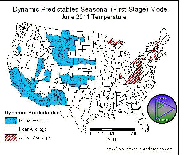
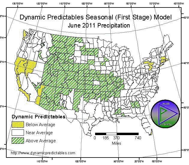
20110517, Tuesday May 17, 2011. Covering all 344 continental US NCDC climate divisions, DynaPred's Seasonal (1st
Stage) Model Outlook downloads follow. Then Press Release: June (201106) DynaPred's Seasonal (First-Stage) Model Outlook:
June (201106) Temperature, download dynapred_1106temp.gif (78kb)
June (201106) Precipitation, download dynapred_1106prec.gif (92kb)
|
|
|
|
Press Release: Dynamic Predictables 201106 OUTLOOK issued 3 PM CDT 20110517
Dynamic Predictables releases for pubic use their Atlas
First Stage predictions for 30-day mean temperature and cumulative precipitation on the Tuesday prior to the third Thursday of each preceding month. Graphics with pattern and trend information for the United States
NCDC climate divisions can be viewed at: http://www.dynamicpredictables.com
June 2011 temperatures will be cooler than usual from Great Plains west.
Eastward of the Plains temperatures will be near seasonal average with exception of along the Appalachian Mountains and upper Great Lakes predicting warmer.
June 2011 precipitation predicts average to above from the Mississippi
River west through the Mountain Time Zone with central being most above, mixed in Southern and Northern Great Plains. Otherwise precipitation predicts near average east of the Mississippi with spotted dry in
Northeast.
** All areas have a prediction. There is no default to climatology (EC),
i.e. an equal likelihood of ABOVE AVERAGE, NEAR AVERAGE, and BELOW AVERAGE.**
|
DYNAPRED 1ST STAGE (SEASONAL) MODEL JUNE 201106
ST TMP PCP ST TMP PCP ST TMP PCP
|
|
WA A A OR A A CA N A D
|
|
CA S C D ID A W
|
|
NV C A MT C W AZ C W
|
|
WY C W UT C W CO C W
|
|
NM C W ND C W SD A A
|
|
NE C W KS C W
|
|
OK A W TX A A MN A W
|
|
IA C A MO A W AR A W
|
|
LA A A WI A A IL A W
|
|
MS A A OH W A KY W A
|
|
MI W A IN A A
|
|
TN A A AL A A NY A A
|
|
VT W A NH W D ME A D
|
|
MA A D CT A D RI A D
|
|
PA W D NJ A A
|
|
WV W A MD A A DE A A
|
|
VA W A NC A A SC A A
|
|
GA A W FL A A
|
LEGEND
TEMP TO NORMAL PCPN TO MEDIAN
W -ABOVE (WARM) W ABOVE (WET)
A NEAR AVERAGE A NEAR AVERAGE
C -BELOW (COOL) D BELOW (DRY)
Contact: GREGG SUHLER at 1-573-815-0520 or SUHLERG@DYNAPRED.COM
or AL PETERLIN at 1-717-731-8804 and Al.Peterlin@dynapred.com.
July 2011 Temperature and Precipitation Atlas First-Stage Predictions will be
released on Tuesday June 14, 2011 at 3PM CDT (2000GMT).
|
|
|
